n 1942, a squadron of aircraft were being ferried from the USA to England as part of the lendlease of military equipment in WW II. The path would take the aircraft from Maine to Labrador to Greenland then Iceland and finally to Scotland. Weather and enemy tactics resulted in the squadron being forced to crash land on the Greenland ice sheet on July 15. While all crews (25 members in total) were safely rescued, the abandoned aircraft were swallowed up by the snow and ice in no time. In the late 1970's, release of military records stimulated groups to consider recovering the "lost squadron".
Problem
The Lost Squadron consisted of six P-38 Lightning fighters and two B–17 Flying Fortress bombers. At first, it seemed that returning to the site and clearing some snow would be all the aircraft buffs had to do to easily acquire the vintage aircraft.
The recovery proved more challenging than first anticipated. There was no surface evidence of aircraft and the icesheet was constantly moving towards the coast.
To successfully recover the aircraft, search teams needed subsurface mapping methods suitable for detecting the buried squadron.
GPR Contribution to Solution
SA combination of historic photos, understanding of ice movement and subsurface sensing systems such as GPR and magnetometry led to success. Over the course of a decade and after several expeditions, technological advances helped pin-point the Lost Sqadron’s location. During that period, more advanced GPR systems appeared, and when combined with the advent of GPS, enabled reliable and repeatable subsurface imaging.
Glaciers and ice sheets are excellent environments for GPR. Detecting localized structures, melt channels and annual layering are common applications. Looking for large metal objects just beneath the snow surface seemed like an easy challenge.
As illustrated, GPR can detect the buried aircraft since the metallic airframes are strong reflectors of GPR radio waves. Recording data while transversing the surface with a GPR system, the aircraft will be visible as bright reflections in the uniform background snow and ice. Finally, in the early 1990’s success occurred and the Lost Squadron was located!

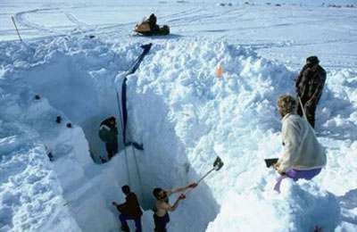
The data example is along a transect that passed over Glacier Girl, a P-38 located at a depth of 85m (about 300 ft). This depth of burial was surprising; further, there would be no simple digging up the squadron members.
Excavation to this depth proved to be a real challenge. The problem was creatively solved by establishing a hot water feed to a large metal probe that melted its way down to the aircraft. Once the vertical shaft was enlarged, Glacier Girl was disassembled and hauled to the surface.
Glacier Girl was recovered in almost perfect condition considering she had spent 50 years buried in the ice! The disassembled aircraft was shipped to Middlesboro, Kentucky where the aircraft historians returned her to her original state after 10 years of meticulous work. In September 2002, Glacier Girl took the air again.
Since then, Glacier Girl has made many appearances at airshows and has even appeared in the movies. She can be seen today at the Aircraft Museum in Middlesboro, Kentucky.


Results & benefits
Glacier Girl's location and recovery demonstrate the power of GPR in favorable environments. Some key benefits are:
- GPR enables rapid subsurface mapping with sub-meter resolution
- Modern instruments are lightweight, battery-powered and portable, suitable for hand-tow or skidoo-towed deployment
- Operation is simple and intuitive with complete digital data recording
- Integrated GPS data acqusition yields geo-referenced data
- Geo-referenced GPR mapping simplifies data analysis and reduce false alarms
References:
David Hayes, 1994, The Lost Squadron, The Madison Press Limited
Many thanks to Bil Thuma for his contributions on recounting the search effort.


