The risks associated with accidentally hitting a buried pipe or cable are high.
23%
of reported damages in the US caused by insufficient locating practices
DIRT (Damage Information Reporting Tool) Report 2016
82
Every 82 seconds a utility line is hit
2020 DIRT report
$4
saved per $1 spent on SUE
Federal Highways Administration
£300-£2800
is the cost of a Utility strike in the UK
University of Birmingham, UK
Prevent damage by accurately locating all buried pipes and cables prior to excavation. Ground penetrating radar can be used as part of the utility locating workflow to provide more complete locates and reduce risk.
GPR can detect traditionally non-locatable subsurface features including
- Metallic & non-metallic pipes (PVC, Asbestos cement, Concrete storm and sewer systems)
- Utilities with broken or damaged tracer wires
- Underground storage tanks
- Drainage tiles
- Non-utility structures (Vaults, Foundation walls)
GPR complements traditional Electromagnetic (EM) Technology by:
- Delineating utilities in close proximity
- Providing reliable depth estimates
- Allowing for data visualization to better map the subsurface
- Reporting and archiving results for future reference
- Integrating data with third-party software (eg. Google Earth)
From simple paint marks on the ground to georeferenced depth slices, our GPR products can provide clear and concise results to prevent damage and manage underground assets.
Locate & Mark™
Quickly & accurately locate buried pipes and mark their location on the ground in real-time while on-site
Real-time, in field locates
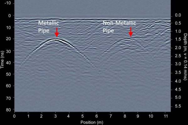
Simply walk the system back and forth over an area, and buried targets will appear as hyperbolas under the surface. Backup until the red line aligns with the center of the hyperbola. This is the location of the buried pipe or cable.
Locate & Mark traditionally “non-locatables”
GPR can locate both metallic and non-metallic pipes and cables. This provides a complete picture of the underground, and helps to ensure that nothing was missed using traditional locate methods.
Metallic & Non-Metallic Pipes
Gather depth information of buried infrastructure
This example shows the location of a concrete storm sewer. GPR was able to find this “non-locatable” and determine the depth of the utility and that it was on a slope, aiding with horizontal direction drilling planning.
3 Line Scans over a Sloping Concrete Storm Sewer
Utilities close to each other
GPR can map all utilities in a single survey. With the availability of in-field interpretations and viewing options, the multiple utility lines can be mapped easily on-site.
Utilities close to each other
Verify locates with GPR
GPR is often used to verify locates performed using other technologies. Many companies hire GPR service providers for peace of mind that their site is fully cleared and accurately marked prior to beginning excavation.
GPR cross-section over a Utility
Locate abandoned or untraceable utilities
GPR can locate abandoned and non-locatable utilities that may not be detected with traditional methods. In this example, the utility on the left could not be located using an EM pipe and cable locator. The GPR easily mapped the two utilities in the area, to ensure proper action could be taken prior to excavation.
Abandoned or non-locatable utilities
Find all buried infrastructure
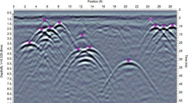
GPR can also locate non-utility features, such as underground storage tanks (UST). The example here shows 5 storage tanks.
Line scan of 5 buried storage tanks
In-Field Visualization
Advanced viewing options provide full understanding of buried infrastructure while still in the field.
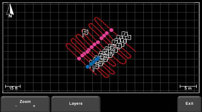
MapView
When using an external GPS, you can add flags and field interpretations on targets in the GPR data and quickly visualize them using MapView. This bird’s eye view helps to differentiate point targets from utilities and helps to correlate the GPR results with site drawings.
Grid Scan
Using a grid scan of a complex area, you can visualize linear utilities at varying depths. This helps to provide an understanding of the subsurface while still on site.
Visualize Complex sites
Using a grid scan of a complex area, you can visualize linear utilities at varying depths. Even closely spaced utilities can be detected as individual lines. This example shows eight buried pipes in a relatively small area.
Map abandoned utilities
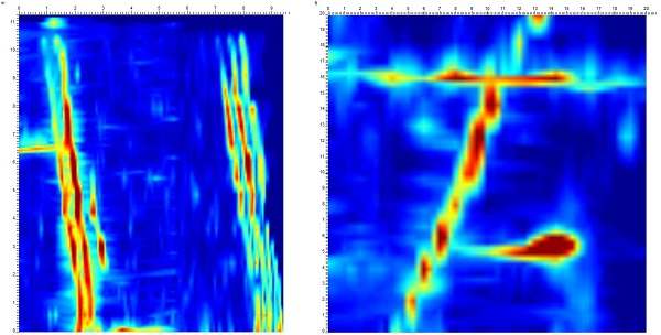
GPR can map abandoned, non-locatable utilities that may not be detected with traditional methods. In this example, the utility shown on the bottom was capped and could not be located using traditional pipe and cable locators. A grid scan was collected over the area; the depth slices identifying the abandoned, capped utility.
Abandoned and non-locatable utilities
Subsurface Utility Mapping (SUM) and Subsurface Utility Engineering (SUE)
GPR maps buried infrastructure and results can be incorporated in CAD & GIS drawings to help plan for large infrastructure projects
Map Multiple utilities at different depths and made of different materials
Since GPR can locate all utilities, including metallic and non-metallic pipes, a complete picture of all buried utilities at a project site can be completed early in the project planning. This example shows a cast iron pipe and a PVC pipe at different depths in the middle of a busy intersection. This aided in future utility planning
Cast iron pipe and a PVC pipe at different depths
Locate utilities to plan new installations
Using GPS and interpretations, GPR can be integrated into Quality Level B SUE investigations. In this example, closely spaced utilities existed, and city planners wanted to ensure that the route of the new water lines did not interfere with existing infrastructure. The use of GPR helped them to plan the installation with minimal disruptions.
Read Case Study
Quality Level B SUE investigations
Create Stunning Maps and Reports
GPR data is saved and available for post-survey analysis and reporting, providing accurate records for future reference and comprehensive deliverables for your customers
Georeferenced maps and data
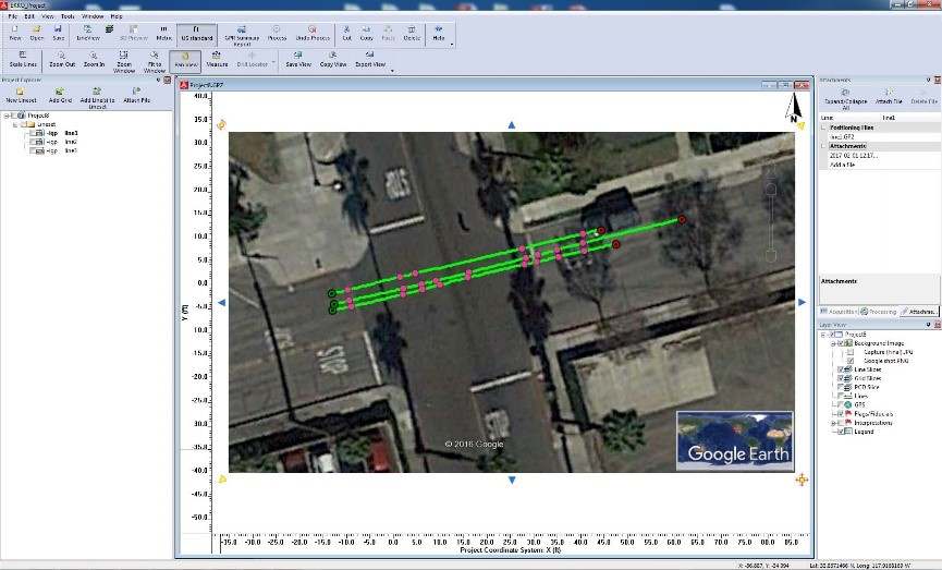
Easily plot images of your data path, screen shots and interpretations in Google Earth. All information is exported seamlessly for viewing in Google Earth and other GIS platforms.
Georeferenced Maps & Data
Create Utility maps in Google Earth
Plotting interpretations on GIS or aerial images and connecting them to show the utility path is a powerful way to portray your locate results.
Utilities on Google Earth
Quickly Produce Summary reports
Take your locates to the next level by providing reports of your findings. Reports can be generated instantly with the EKKO_Project software, included with your GPR system.
Visualize utilities from Line Scan data
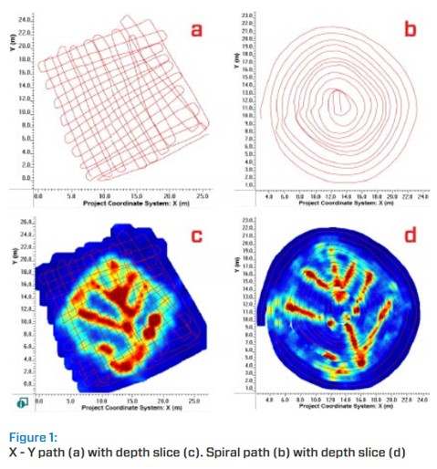
Collect GPR survey lines over large, odd-shaped or difficult-to-survey areas, and then seamlessly turn them into depth slices in EKKO_Project. This example shows two different methods for mapping drainage tiles using varying patterns of line collection. In this case, Line Scan data positioning was done with GPS.
Mapping drainage tiles in Complex Areas
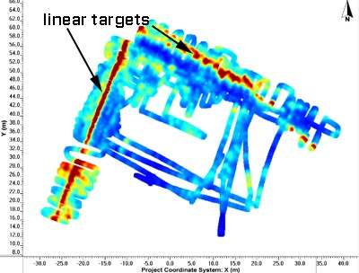
Visualize linear targets over large areas
Map utilities over large areas by collecting GPR lines and then processing them using SliceView in EKKO_Project. Linear utilities can be seen when line data is converted into depth slices, providing another way to visualize underground utilities without the need to set up a grid.
Series of GPR Line Scans & Depth Slices
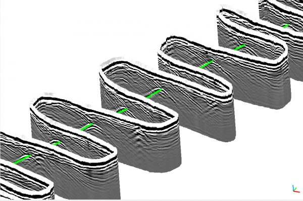
3D Visualization
Depth slices can be viewed or made into 3D views to clearly show buried utilities.
Point Cloud Visualization
Survey large areas with GPR integrated with GPS and then seamlessly turn them into a 3D Point Cloud file in EKKO_Project. This example shows hyperbolic responses from a linear utility crossed several times while collecting GPR data on a road.
Point Cloud Visualization
Sensors & Software GPR Systems
Advantages
- Easy to use, flexible operation
- Ground-coupled GPR to provide the best quality, deepest penetration and highest resolution data possible
- Intuitive and powerful processing software to efficiently analyse and report results
- Georeferenced data collection for integration into GIS systems
- Industry recognized GPR expertise and support to help you maximize your GPR returns
We offer a selection of systems for utility locating, so you can choose the one that is best for your project needs.
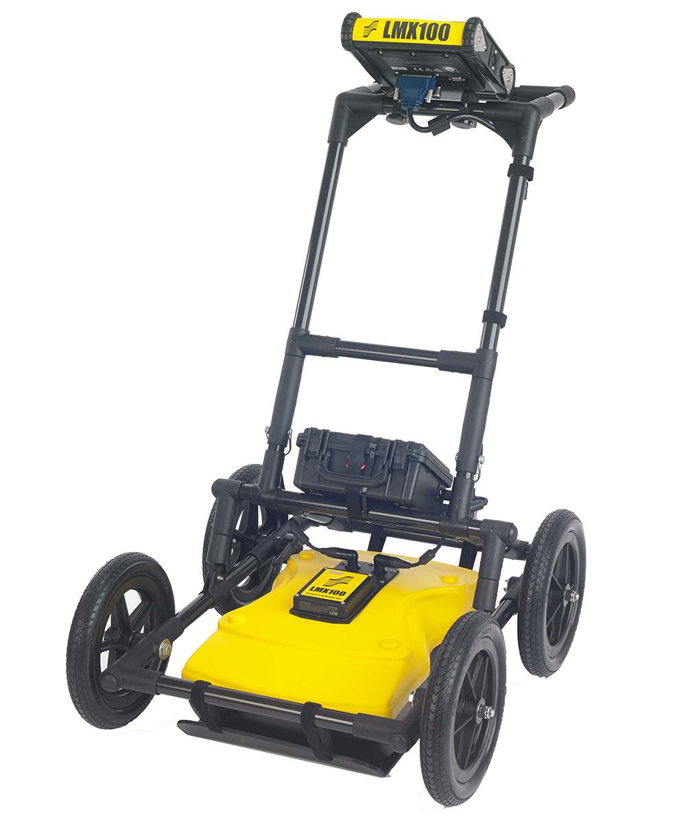
The simple, affordable way to locate and mark utilities in the field. Rugged and lightweight, the LMX100™ is designed for rapid deployment and displaying instant results. Features include touchscreen, internal GPS, and wi-fi capability.
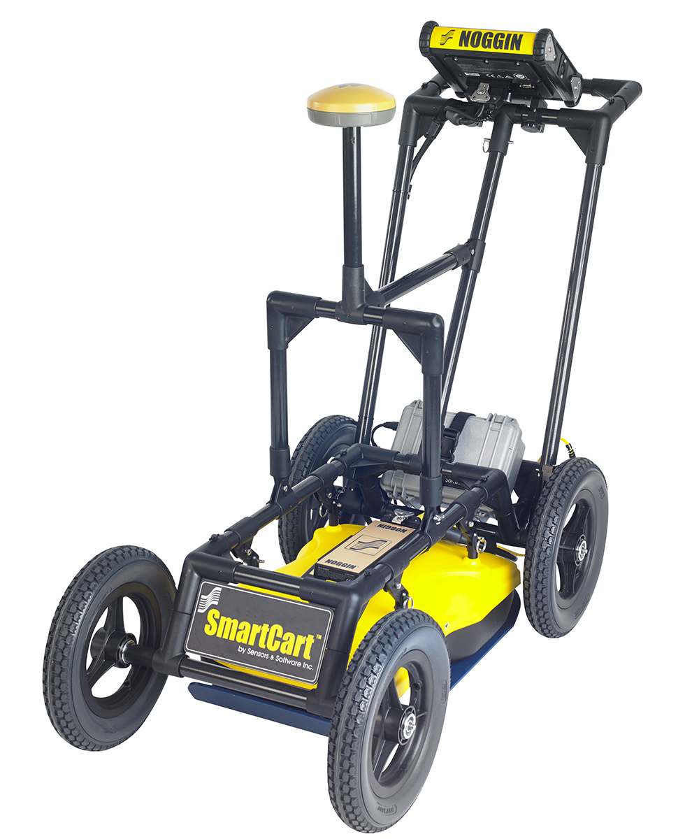
The premier GPR for locating professionals features all the capabilities of the LMX100™ plus the ability collect data in grids and process to create depth slices in the field in seconds! Optional external GPS available. Optional data export for post processing in EKKO_Project™ PC software.
The Noggin® offers the ultimate in flexibility. Choose between four different center frequencies and four different configurations to suit your application. Noggin systems also offer custom data acquisition options for non-traditional locating projects.
To determine the best product for your application please contact us


