ubsurface utility mapping and engineering for a new transit system deployed a ground penetrating radar (GPR) to locate the position and depth of buried infrastructure. Identifying potential conflicts and issues early in the design process helped ensure the project proceeded according to schedule.
Problem
Design and planning new construction requires detailed understanding of potentially conflicting subsurface structures. This case study shows GPR used in the subsurface utility mapping and engineering(SUM/SUE) process for a new transit corridor.
The objective is to identify the location of all buried infrastructure, survey its position, create digital map layers and identify conflicts with new construction plans.
GPR Contribution to Solution
GPR is commonly used to locate buried infrastructure, including concrete and plastic pipes, abandoned pipes and cables as well as old foundations, ducts and chambers.
For this exercise, a Noggin® 250 GPR on a SmartCart® was used. A LMX200™ GPR system could also have been used to get the same results. GPR identified features are normally marked out with paint or markers on the surface. The geo-referenced location of the detected targets are recorded and entered into a database of GIS systems to render multiple layer digital maps.
The ASCE 38–02 standard for SUE provides guidance on the mapping deliverable. Steps entail reviewing utility records, verifying and locating on site, and sometimes excavating to expose targets for full identification and characterization.


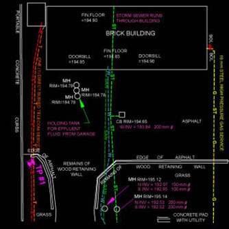
The GPR survey of this site found a number of buried pipes and cables. This information was incorporated into CAD drawings and used in the construction planning process. Knowledge of the location and depth of gas lines and other buried infrastructure allowed city planners to find the best route for the new transit corridor.

Results & benefits
GPR surveys provide a complete picture of subsurface infrastructure. The benefits of using GPR include:
- Simple deployment on site
- Immediate visual response with accurate depth estimate
- Detection of a variety of buried obstructions
- No requirement to hook-up to the target
- Complements the use of EM induction, magnetics and vacuum excavation
GPR is commonly used in subsurface utility mapping and engineering to provide accurate location and depth of underground assets. Using this information to update maps and identify potential design conflicts saves both time and money in the engineering design process.
Download the case study: Subsurface Mapping Helps Transit Design


