ydrologists and engineers often require accurate water depth and information about sub-bottom stratigraphy in shallow freshwater lakes and rivers. Uses can vary from estimating available water volumes to the engineering design of new structures.
Problem
Many small lakes, weed-invested waters, and fast-flowing streams are difficult areas in which to get reliable water depth or to define sub-bottom structure. Projects such as bridge or pipeline crossings need substantive subsurface control data. Use of large boats with conventional acoustic sounding equipment is often not possible.
GPR Contribution to Solution
Many bodies of freshwater are quite transparent to radiowaves, much to the surprise of many people. Depending on the level of dissolved solids (essentially salinity), GPR can actually see through many meters of water.
The compact nature of GPR instruments and the integration of modern units with GPS positioning makes GPR a natural tool for these applications. GPR surveys can be conducted from boats, rafts, or even through the ice in areas where open water freezes.
The compact nature of GPR instruments and the integration of modern units with GPS positioning makes GPR a natural tool for these applications. GPR surveys can be conducted from boats, rafts, or even through the ice in areas where open water freezes.
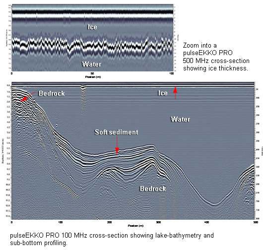
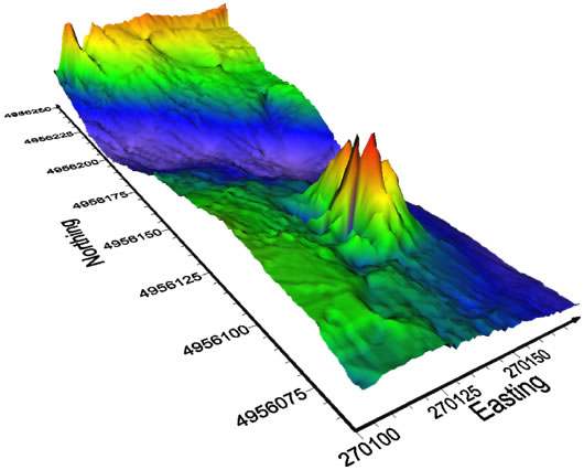
The present case study illustrates results obtained on a small freshwater lake in the Precambrian Shield in Canada; the water depth, soft sediment layer, and rock boundary are shown. Surveys were conducted using a canoe and rubber raft in summer and a sled towed unit operating through the ice in winter.


Applications for GPR bathymetry abound. In northern regions through-the-ice bathymetry can be invaluable.
While these results are spectacular, some fresh water lakes can have substantial salt content. Though still considered fresh, the water electrical conductivity can be elevated by the presence of winter road salt run-off, natural rock solutioning, human or agricultural waste dumping, and fertilizer dissolution. The electrical conductivity of a large river has been seen to jump ten-fold when winter snow was disposed of directly into the river.
Results & Benefits
GPR bathymetry is a little-appreciated GPR application. Some key benefits are:
- Ability to survey hard-to-access areas
- Ability to see though shallow water and determine subsurface structure
- Simple and easy-to-use GPR systems like the pulseEKKO PRO and Noggin units make field operations practical
- Integrated operation with GPS delivers geo-referenced interpretations
- Users can be effective with minimal training
- Unified data analysis delivers geo-referenced results
Download the case study: GPR Bathymetry
Click here and learn more about pulseEKKO® PRO and SPIDAR® GPR


