A
gricultural drainage systems have been in use worldwide for centuries. Some systems are constructed of modern plastic piping while others are made of clay tiles and some are even stone filled trenches. Locating and determining the condition of these drain systems represents a major challenge as there are seldom records of their location.
Problem
Knowing the location of the piping is the critical first step in assessing the state of a drain system. The depth and slope and degree of blockage are critical pieces of information.
Since the drain materials rarely contain metal, GPR represents a viable method for detecting and determining the locations of drainage pipes. While GPR is able to detect non-metallic structures, many agricultural fields are clay-rich fertilized soils which are highly attenuating to GPR signals. Seeing deep enough to see the drains is a challenge.
Since the drain materials rarely contain metal, GPR represents a viable method for detecting and determining the locations of drainage pipes.
GPR Contribution to Solution
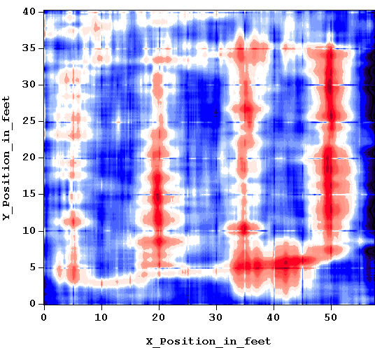
This study was carried out by the USDA and researchers at the Ohio State University. The goal was to assess if detailed area coverage surveys could overcome the high loss environment obstacle. The concept was that a large number of GPR observations might show a pattern of soil disturbance since drains are generally linear segments leading to a common collection point.
The GPR field polaization and line orientation would be varied as well in the the hope that some combination of survey parameters would yield a detectable pattern.

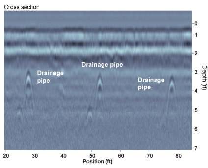
A controlled test site was available near the university; a clay-rich fallow field contained plastic pipes at a depth of 1 to 2 m. Surprisingly, the pipes were actually detectable on single profiles as distinct hyperbolic reponses in many areas.
Data acquired on a regular grid of lines using a Noggin® 250 MHz SmartCart® configuration showed the regular pattern of the drain pipes and corroborated the concept that the patterns could be discerned.
Following this initial evaluation, a more extensive research program has ensued with more field tests and numerical simulations which are now being reported in the scientific literature.
Results & Benefits
The above examples demonstrates the value of GPR for agricultural drain mapping. Some key observations are:
- The compact portable and rugged Noggin® 250MHz SmartCart® configuration proved ideal for this project.
- The SmartCart with integrated odometer and GPS synchronized data recording is ideally suited to obtaining accurately positioned data over large areas
- Systematic search protocols should be developed to ensure optimal results.
- In some instances the individual target responses can be visible allowing use of simple locate and mark methodology
- Grid mapping can simplify data analysis and enable subtle patterns to be observed that would not be readily interpreted in simple GPR cross sections.

Download the case study: Noggin® 250 SmartCart® surveying for drainage tiles


