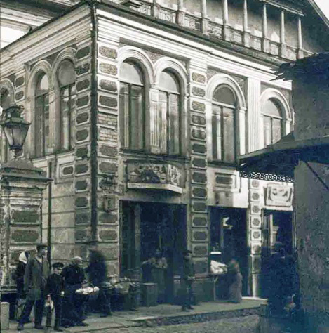
ixty years after the Great Synagogue and Shulhoyf of Vilna (Vilnius) was razed, a team of international scientists is uncovering precious history with the assistance of pulseEKKO® ground penetrating radar (GPR).
The city of Vilnius has been recognized as an important cultural and scientific hub as far back as the mid-1500's. By the end of the 17th century, Vilnius had a reputation unrivaled in Europe for having the largest number of churches of different faiths.
One such establishment was the Great Synagogue of Vilna. Over time, the Great Synagogue became surrounded with other buildings within the labyrinth-like Shulhoyf, a complex of twelve synagogues and other communal institutions. As World War II ravaged Europe the Great Synagogue was looted and burned, leaving the buildings empty and absent its former glory. In 1957, the Soviet Union, then in control of Lithuania, demolished the structure to provide space for a boulevard, and years later built an elementary school. Researchers believe the Great Synagogue was demolished by imploding it in on itself with nearly all the collapsed structure being left on site.

In 2015 a group of international scientists, headed by Dr. Jon Seligman of Israel Antiquities Authority were commissioned to research, uncover and preserve the remnants of the Great Synagogue of Vilna. After some preliminary excavations, it was decided to use Ground Penetrating Radar (GPR) to scan the site. GPR could provide an economical way to non–destructively scan the area to identify where there was a higher likelihood of finding intact sections of the foundation. Dr. Harry Jol of the Department of Geography and Anthropology from the University of Wisconsin–Eau Claire was chosen to be the GPR project leader due to his extensive experience with the technology.
The initial work done with a pulseEKKO® GPR system took place during the summer of 2015 (Figure 2). Six grids with a line spacing of 0.25m were collected, totaling over 1600 square meters (Figure 3). The 225 MHz antenna provided an excellent view penetrating to over 3 meters into the subsurface (Figure 4) and gave indications of where the ancient complex might be intact.


Looking at archaeological GPR data, well-defined circles, squares, and lines in depth slice maps are strong indicators of human interaction with the landscape. It is also important to review cross-section data because features like ancient floors and walls can often be seen more clearly in this view (Figure 5).

In 2016, excavations were conducted based on the information from the pulseEKKO® GPR surveys. These excavations allowed for the exact nature of the GPR responses to be determined. Excavation began by removing the top organic fill. Soon after, the top of some walls from a number of individual rooms became visible. Upon further analysis, it was determined that the walls were those of the bath house, a key part of the synagogue complex. Figure 6 shows a number of the findings.

Due to the success of the GPR surveys, two more grids were collected in the summer of 2016. Excavations are planned for the summer of 2017 to further investigate the geophysical findings.
pulseEKKO® GPR systems are favored by archaeologists for their ability to see deep into the subsurface while giving excellent visualization of ruins, cavities, graves and buried ancient roads. For the Great Synagogue of Vilna, this means that while the structure was flattened, it was not entirely erased and will continue to be a part of Vilnius’ great cultural heritage.
Special Thanks to Thomas Wavrin in cooperation with Harry Jol PhD and www.seligman.org.il
Full Reference:
Subsurface Imaging to Aid in Identifying the Remains of the Great Synagogue and Shulhof of Vilna in Vilnius, Lithuania Thomas Wavrin–Harry Jol, PhD University of Wisconsin; Eau Claire Department of Geography & Anthropology
Click here to learn more about pulseEKKO® Ground Penetrating Radar.


