


The latest release of the LMX150 FINDAR GPR system data acquisition software adds real-time visualization tools to improve your locating workflow. The addition of SplitView and enhanced MapView make it easier to understand and track utilities on-site for a more complete locate.
Ground Penetrating Radar (GPR) is widely used for utility locating to identify and mark underground utilities. GPR complements traditional pipe and cable EM locators by allowing you to locate both metallic and non-metallic utilities, including concrete storm and sewer systems, underground storage tanks (UST), drainage tiles, fibre optic cables and non-utility structures (such as vaults, foundation walls & concrete pads). LMX® GPR systems are designed and optimized for utility locating, making it easy to add GPR to your locating workflow.
The latest release of data acquisition software for the LMX150™ FINDAR® GPR system, a compact high resolution, utility locating system, now includes features for real-time visualization to improve your locating workflow.
The popular SplitView and Enhanced MapView tools are now available on both the LMX200 and LMX150 FINDAR GPR systems. We will highlight their benefits and use cases below.
Enhanced MapView
The addition of Enhanced MapView provides a more complete bird’s eye view of your project site, displaying depth slices from multiple grids simultaneously, interpretations and survey paths from all GPR line scans in your project, and a real-time position indicator so you always know where you are in the survey area (Figure 1).

MapView also provides viewing options to select which features (layers) you would like to display, allowing you to de-clutter your view and only show the desired information (Figure 2). Or toggle through viewing options to visualize different information and build a complete picture of your site.


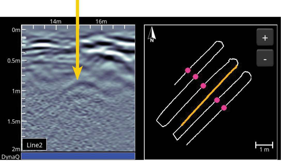
SplitView
SplitView combines data collection with MapView and provides a real-time view of your LineView (cross-section) data beside your survey area and interpretations.
The implications of SplitView are extremely powerful for utility locators. Seeing the subsurface in LineView and MapView simultaneously greatly assists with data interpretation. Add field interpretations by simply touching the top of hyperbolas on the LineView side of the screen. That same interpretation will instantly appear on the MapView side of the screen. Now you can see the spatial relationship between targets and can quickly determine if a series of hyperbolas are linear in orientation, and therefore more likely to be a utility. For example, see the series of pink and blue field interpretations in Figure 3 that show a pair of linear utilities crossing one another.

SplitView can also help you predict where a target may be. By placing interpretations on the screen, as you collect data in a back-and-forth pattern, you can visualize the linearity of buried targets. This can also help you identify potential missing targets. If we see that a series of hyperbolas line up linearly , except for a few missing ones, then you can scroll back in the data to the location of the missing target and take a second look. As experienced utility locators know, hyperbolas from utilities do not always appear as strong responses. Soil conditions have a huge impact on GPR signal strength, and some sites may have localized areas where the GPR signal strength is reduced. Navigating through the data and looking more closely at where you expect a target to be, can help you to identify lower amplitude hyperbolas, as shown in Figure 4.
SplitView can also help you to return to a previous location at your project site. During a utility survey you may locate an object on the GPR data and place an interpretation on it (pink dot in Figure 5). Now, if you want to return to that location, simply look at the MapView screen (Figure 5) and navigate as your current position (blue dot) moves toward the interpretation you marked earlier. This can also be used to navigate to other areas at the project site.

These new features on the LMX150 FINDAR unlock a world of possibilities for locating and following the path of utilities, helping you to quickly and accurately mark and map utilities on your job sites. The ability to see your GPR data in real-time beside your survey path helps to differentiate utilities from other buried features.
If you are a current user of the LMX150 FINDAR system, or the FINDAR GPR, and would like to upgrade your system to the latest software, visit our software downloads page for instructions on how to update your system.
For more information on LMX® GPR for utility locating, visit our website.


