


GPR Helps Solve the Mystery of the Hole in the Dune
Mt. Baldy, in the eastern part of the Indiana Dunes National Lakeshore, is the largest active dune along the southern Lake Michigan shoreline and a popular recreational facility for local residents and tourists (Figure 1). In July 2013, a 6-year-old boy walking on the dune fell into a hole that suddenly opened up underneath him. He was trapped for several hours more than 3 m below the surface until emergency workers dug down to rescue him (Figure 2). Afterward, because neither the formation process or the extent and significance of the hazard represented by this hole was known, Mt Baldy was closed to foot traffic in 2013 and remains so today.
 Figure 1: Location of Mount Baldy
 Figure 2: Rescue of boy trapped in the hole in the dune (Arizona Daily Star)
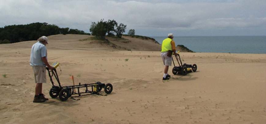
To understand the development of these voids, a study of the architecture of the dune was undertaken by the Indiana Geological Survey 1 and Indiana University’s Geological Sciences Department 2 using GPR and solid-earth cores. A pulseEKKO PRO GPR system with center frequencies of 50 and 100 MHz and a Noggin 250 MHz system (Figure 3) were used to collect survey lines perpendicular to the shoreline and longitudinal to the direction of sediment transport of the dune (Figure 4). Since the dune has a large amount of topography, to reconstruct the true geometries of the various layers and features, it was necessary to correct the GPR lines for the elevation changes in post-processing.
 Figure 3: pulseEKKO PRO with 100 MHz antennas (left) and Noggin SmartCart with (right)
 Figure 4: Three 250 meter and thirty-three 80 meter GPR lines were collected for the investigation
The data from the GPR transects and cores were used to define four major stratigraphic horizons. These include an upper and lower dune, separated by a paleosol (an ancient soil horizon) that developed on the top of the lower dune (Figure 5). The upper dune formed during the 20th century and corresponds to present-day Mt. Baldy; the lower dune formed 3000-4000 years after ancestral Lake Michigan fell from the peak mid-Holocene water level after the retreat of ice from the last ice age.
 Figure 5: Image of ancient soil (paleosol) the trees grew on before being buried by the advancing dune sands.
This study shows that the voids that closed Mt Baldy were apparently caused by trees that were rooted into the paleosol that occurs on the surface of the lower dunes. The trees were buried and died as the sands that make up Mt. Baldy migrated landward during the early 20th century. These trees and paleosol are now being slowly unearthed as the dune continues to migrate. As they are exhumed, the trees decay in place through fungal growth; this creates voids of variable size, depth and orientation, depending on the diameter and density of the buried tree trunks and limbs. Fungus on the trunks when first buried probably rots the tree from base to top when exhumed. Thus, the risks of voids opening in the dune are depth and time dependent; the buried trees seemingly must lie within 3-5 m of the surface to allow fungal growth to resume and the elapsed time between burial and exhumation must be short enough so that the fungus does not die when deeply buried.
Nathan’s hole (named after the rescued boy) is apparent on GPR profiles and can be seen as disrupted bedding on the 80 meter long transect that passed over the excavation to recover him (Figure 6). Interestingly, while the upper beds were apparently disrupted during excavation, it is believed that narrow, strong vertical reflectors below the hole represent a tree trunk that extends to the paleosol surface and may be responsible for the void in which Nathan was buried. The reflectors probably represent greater moisture in the rotting trunk.
 Figure 6: 80 meter long GPR profile collected with a Noggin 250 system. The location of “Nathan’s hole” and the interpreted rotting tree that caused it are indicated.
Initially, geologists were baffled about what natural forces were responsible for creating voids in a dune and wondered if this was some new and unknown process that had never been seen or documented by researchers. But careful study and detailed GPR images helped to piece together a story that makes sense with known natural processes and solves the mystery of the holes in Mt. Baldy.
Story courtesy of William Monaghan1, Todd Thompson1, Erin Argyilan2 and Kevin Russell2
Read about Tips – Forensic Investigations
Read about Streamline your Data Collection with SmartChariot


