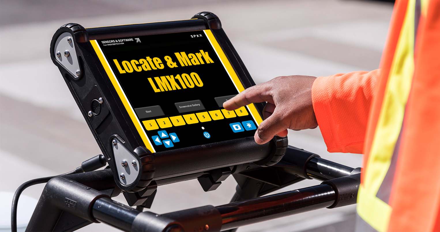
LMX100™ GPR Underground Utility Locator
close X
Nav Menu
 

LMX100™

Locate & Mark®
Underground Utility | PVC Pipes | Cables

Utility locating with GPR made simple

As one of the most affordable GPR utility locating tools in the market today, the LMX100™ completes the locator’s toolbox, offering a more complete picture of the underground infrastructure. With a simple, easy-to-use interface it also offers the perfect balance of depth penetration and high resolution for accurate locating.

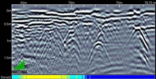
The LMX® family is a non-destructive Ground Penetrating Radar (GPR) that can locate utilities that cannot be located using traditional methods (e.g. plastic pipes or utilities that contain broken tracer wires).

LMX® has the advantage of detecting:

  • Metal utilities, including pipes and cables
  • Non-metallic pipes, including PVC and asbestos cement
  • Concrete storm and sewer systems
  • Utilities where installed tracer wiring has failed
  • Underground storage tanks and drainage tiles
  • Septic system components
  • Non-utility structures such as vaults, foundation walls and concrete pads
LMX100™ Features
LMX 100 utility locator gpr

Enhance your productivity and increase your confidence when locating metallic & non-metallic utilities with these features:

Data collection made simple

The LMX100™ does the thinking for you, with all the data collection parameters pre-set so that you can quickly start your survey and know that your data collection is optimized.

gpr geophysical survey system

Quickly start your survey
Press Start and begin your survey right away with no initial settings required.

GPR data

No prior settings required: Detect shallow and deep utilities simultaneously
LMX® systems have ultrawide band (UWB) antenna allowing it to detect shallow and deep utilities in one pass.
depth of underground utility

Easily pin-point the location and depth of a utility
Locate & Mark™ mode incorporates a back-up feature to enable you to accurately locate targets and mark them on the ground. To locate a feature, simply roll the system back along the same path until the red vertical line is exactly over the response. You can mark the location of the object on the surface and continue data collection. Quickly display the depth of the feature by adjusting the cross-hair to align with the target.
lmx utility locating dynat feature

Intuitive calibration for accurate target depths with Soil Cal
Select from pre-set Soil Cal values or use the simple hyperbola-fitting method to match the target and the depth calculations will be updated instantly.
utility locating gpr

White = No Data (too fast!) | Yellow = Moderate quality | Light blue = Better quality | Dark Blue = Highest quality

Optimize your data based on your survey speed with DynaQ®
DynaQ® is our patented Dynamic Quality technology that stacks automatically depending on your survey speed. Stacking increases the depth of penetration by suppressing the background noise. A slower survey speed results in more stacks and faster speeds result in less stacks and the operator is always able to see by a color coded indicator the level of stacking applied. Highest data quality can be achieved at a comfortable walking speed.
In-field Image Optimization

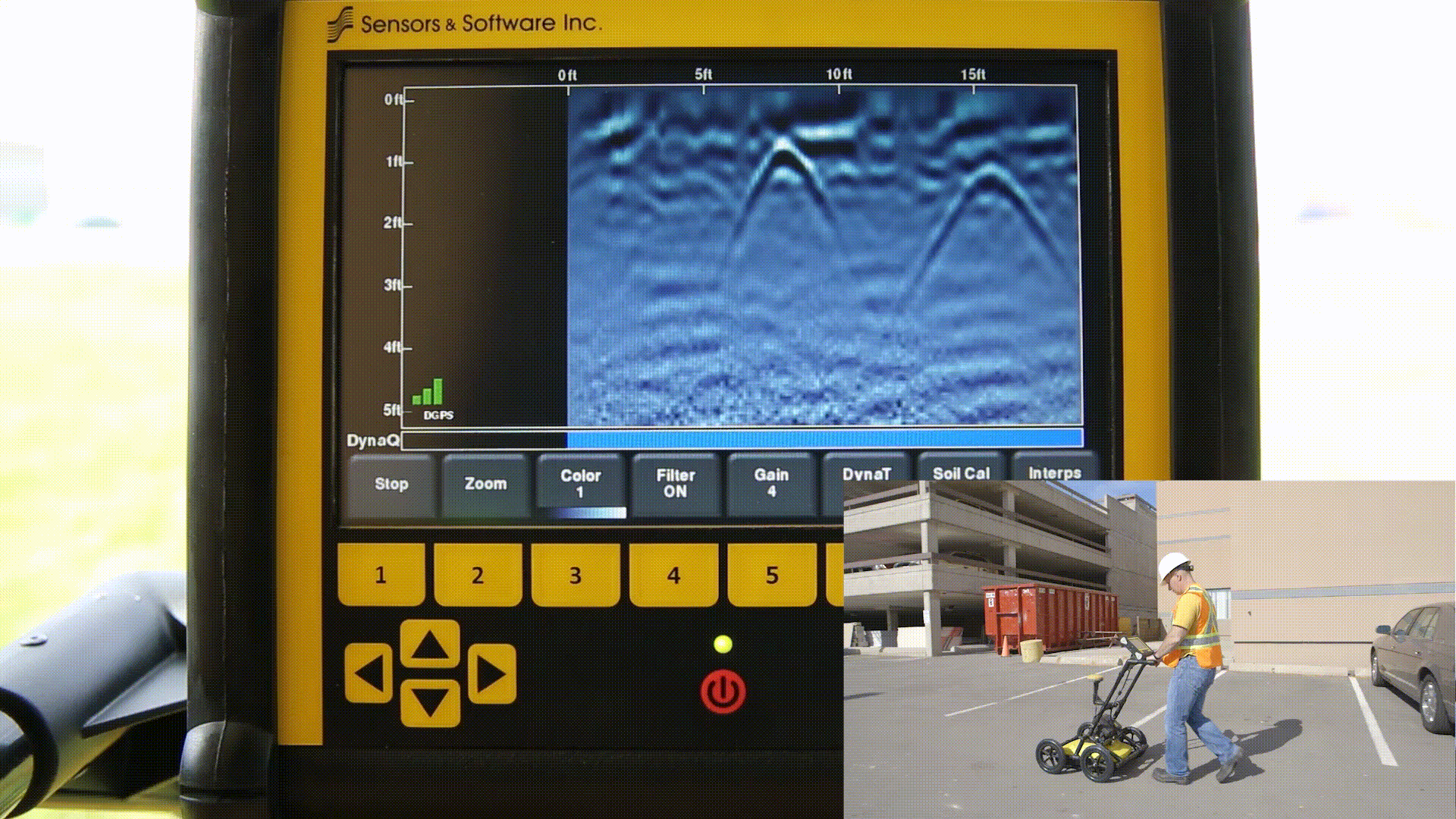
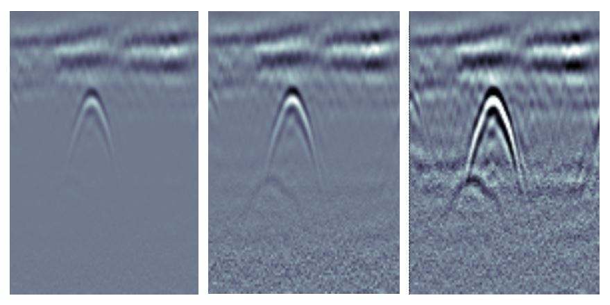
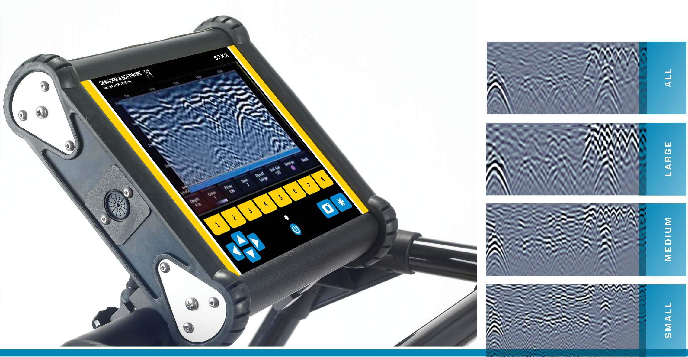
One can also select from the available in the field image optimization settings such as:

gpr-datagram-noise-filter

Filter
Select from 5 predefined background subtraction filters on the display unit to remove flat-lying responses in the data to aid in identifying shallow targets and enhancing the visibility of hyperbolas at deeper depths
gpr scanning
Gain
Cycle through pre-set gain settings to maximize the visibility of targets.
lmx utility locating dynat feature
DynaT™ (New Feature)
DynaT™ is our patented Dynamic Target enhancement feature that optimizes views of small, medium and large targets. These views can be toggled to reveal additional subsurface features, giving you unprecedented insights and target confidence in the field.
File Management & Data Export

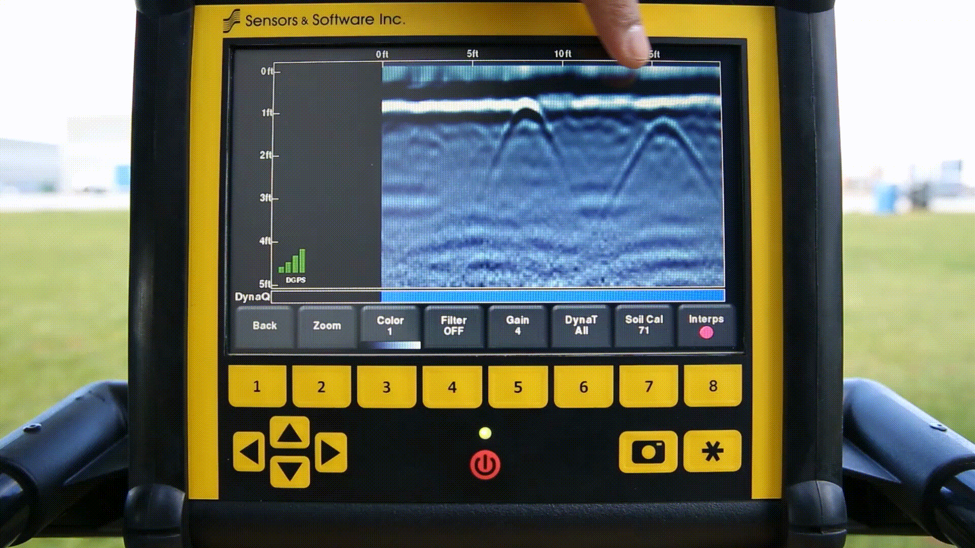
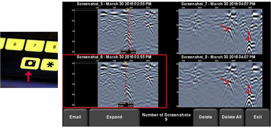
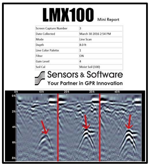
LMX100™ also offers on-site data image capture saved in an organized manner for easy reference and sharing:

utility mapping screenshot

Screenshot Gallery
The screenshot gallery allows you to manage all the screenshots saved on the LMX100™. From there you have the option of viewing, deleting and emailing the screenshot as a mini report.
utility mapping report

Wi-Fi Mini-reports
Easily share your findings in a mini-report directly from the survey site. The mini-report includes a screenshot and useful information about the collected data.
utility map

Geo-tagged KMZ files
Taking advantage of the built-in GPS, the screen captures collected on the LMX100™ are geo-tagged and are readily displayed in Google Earth once data is exported. The LMX100™ automatically exports a KMZ file with all the screenshots, so you can share this and visualize your survey without any extra processing steps.

Contact Us

Lease to Own option available

Leasing Options Now Available!

Contact us today to learn how you can get unbeatable lease options on our full range of Ground Penetrating Radar equipment with low monthly payments!