Noggin: Adaptable, high-performance
ground penetrating radar
Noggin: Adaptable, high-performance ground penetrating radar
Noggin: Adaptable, high-performance
ground penetrating radar

GPR grid surveying on a street in New York City
GPR can be a powerful tool for mapping the location and depth of metallic, non-metallic, plastic, concrete and asbestos-concrete utilities. Mapping with GPR to systematically cover an area can quickly reveal the distribution and character of multiple buried utilities. GPR surveys on regular grids are now recommended in Subsurface Utility Engineering (SUE) projects. This case study illustrates the detection of a PVC natural gas main and an underlying cast iron water line.
Plastic and cast iron pipes are not readily located by traditional methods. This site in New York City was one where the location of plastic gas mains and cast iron water lines were in question. Construction design and planning called for completion of Level B SUE mapping of potential conflicts with existing utilities.
GPR was selected as the method of investigation since it could detect both metallic and non-metallic utilities. To make a complete study, the locating team used a grid survey approach to create a full subsurface view of the critical area.
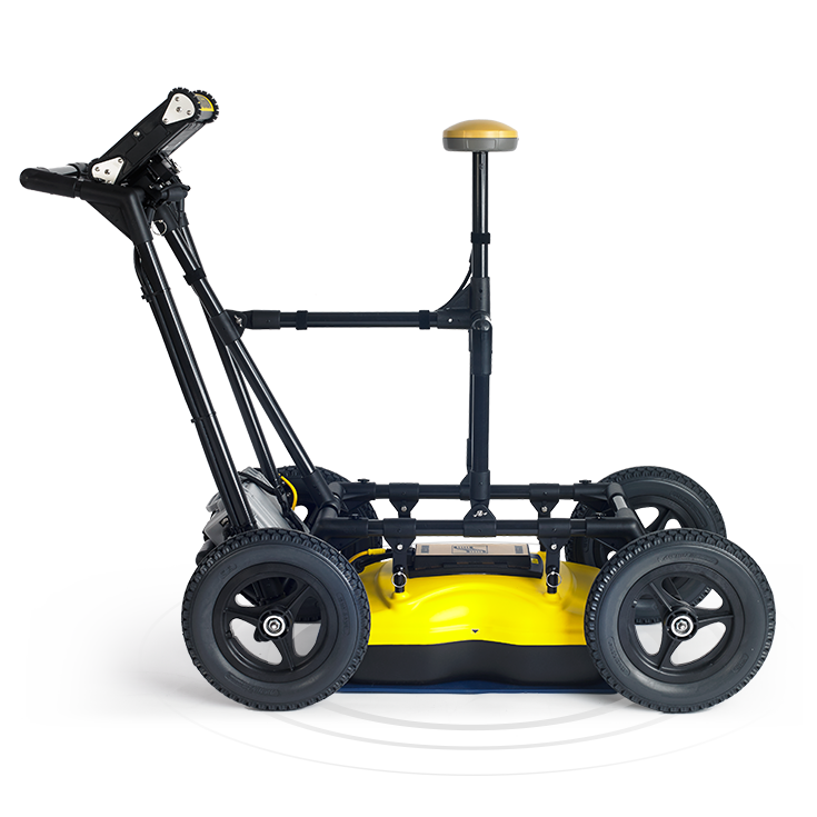
A Noggin 250 MHz GPR in the SmartCart configuration was used. The 250 MHz system provided the optimal trade-off between depth of exploration and target resolution. The SmartCart provided quick and easy maneuvering of the GPR.
An 8 m by 23 m rectangular grid was established and GPR data were acquired on bi-directional lines to cover the area at 0.5m line spacing. All data were acquired in 45 minutes.
Depth slice maps were created on site and allowed infield marking of both the gas and water line location for vacuum exposure if further Level A SUE evaluation was needed.
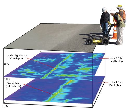
Depth Slice Images showing the located utilities as well as indicated soil disturbances or composition variations. The strong linear features clearly indicate the buried pipe position and depth.
Using the EKKO_Project software, the GPR images were converted to CAD drawing layers ready for import into the project design CAD system.

CAD drawing layers ready for use in the project CAD system by design engineers.
See below the surface with the Noggin
The product featured in this case study is the Noggin 250 deployed in the SmartCart configuration.


* Additional sensors & configurations are also available.


Get in touch with us
See how you can expand your service offerings with Noggin GPR.
Our solutions empower informed decision-making.
Sensors & Software delivers subsurface imaging solutions to customers worldwide. Understanding what lies beneath the surface of materials like soil, rock, rubble, pavement, concrete, water, ice and snow opens endless possibilities.

