
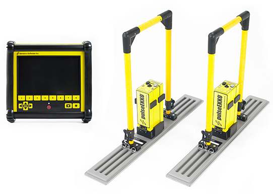
pulseEKKO® For the GPR Professional
Configurations

pulseEKKO® adaptable configurations: quick release fasteners and interchangeable components enable rapid system reconfiguration. Integrated support for GPS, odometers and fiducial markers with triggering from a wide range of inputs provides accurate spatial positioning.
Modes of Operation:
- Step Mode: The pulseEKKO® is positioned, data acquired, pulseEKKO® moved to the next position, and then data acquired again. This is repeated until data are collected from all required locations. This mode is used in applications when highly accurate positioning is required or when surface roughness or obstructions preclude easy continuous sensor movement.
- Monitoring Mode: The pulseEKKO® is placed in a stationary position and data are collected at defined time intervals. The data are then compared over time to identify changes.
- Free Run – Speed The pulseEKKO® data acquisition occurs at defined intervals and unit is dragged or pulled over the area to be surveyed. Spatial position and spatial sample density depend on the ability of the operator to move the unit at a constant rate over the surface and mark spatial reference points.
Environment & application characteristics:
This configuration is designed for manual movement of a pulseEKKO® over smooth to moderately rough terrain. The embedded DVL software provides easy to use Line Scan and Grid Scan mode which logs data in a structured format enabling quick creation of depth slices and post data processing in EKKO_Project and various GIS and CAD packages or in Google Earth. Data is displayed on the DVL-500 in real time and enable real-time target mapping with field interpretations.
Options:
The following optional items are available to customize the system for your needs:
- Bluetooth remote trigger for data acquisition
- GPS to provide georeferenced coordinates for the measurement
- Longer cables to enable acquisition and control from a greater distance
- Smaller or longer-life batteries depending on the time duration of measurements or portability requirements
- A variety of optional handles and ancillary support accessories are available to tailor the Bistatic configuration to user needs.
- Lightweight deluxe carrying harness for DVL-500 for comfortable, hands-free operation
Products:
The Bistatic configuration supports 12.5, 25, 50, 100 and 200 MHz pulseEKKO® antennas.
Mode of Operation:
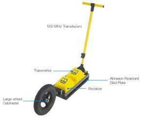
The pulseEKKO® SmartTow configuration is designed for hand-towed surveying over a smooth to rough terrain. The wheel odometer triggers data acquisition at programmable station intervals to provide uniform data coverage. Data acquisition rates change to accommodate survey speed, exploiting Sensors & Software’s unique DynaQ® feature which allows for dynamic stacking (averaging) of data while moving.
Environment & Application Characteristics:
This configuration is best suited for acquisition of data along lines or on regular grids with rough surfaces, such as grassy, brush covered or rocky surfaces. The bi-directional large wheel odometer triggers data acquisition when moved in one direction and provides back-up arrow positioning in situations where the movement can be easily reversed.
Options:
The following optional items are available to customize the system for your needs:
- Lightweight deluxe carrying harness for DVL-500 for comfortable, hands-free operation
- GPS to provide georeferenced coordinates linked to the data.
- Longer cables to enable the display and control unit to be in a fixed position while sensor is moved.
- Smaller or longer-life batteries depending on the time duration of measurements or portability requirements.
Products:
The SmartTow™ supports pulseEKKO® 50, pulseEKKO® 100, pulseEKKO® 200, pulseEKKO® 250, pulseEKKO® 500 and pulseEKKO® 1000.
Mode of Operation:
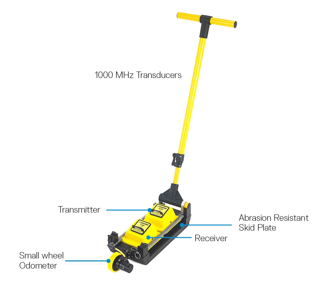
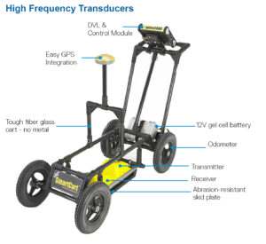
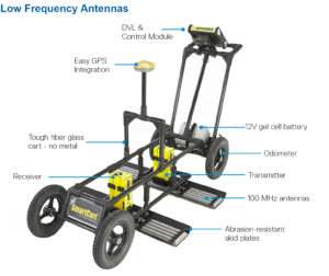
The SmartCart® provides a self-contained mobile platform for transporting the pulseEKKO® and DVL for fast data acquisition. The pulseEKKO® is pushed (or pulled) along a line, with an integrated odometer providing equispaced triggering of data acquisition. Data acquisition rates change to accommodate survey speed, exploiting Sensors & Software’s unique DynaQ® a feature which allows for dynamic stacking (averaging) of data while moving.
Environment & Application Characteristics:
This configuration is designed for manual movement of a pulseEKKO® over smooth to moderately rough terrain. The SmartCart is optimal for surveys where large areas need to be covered quickly and systematically. The embedded software provides eay to use ‘survey & map’ operation which logs data in a structured format enabling quick creation of plan maps that can be displayed with various GIS and CAD packages or in Google Earth™. The bi-directional odometer triggers data acquisition when moved in one direction and provides back-up arrow positioning enabling ‘locate and mark’ real-time target mapping.
Options:
The following optional items are available to customize the system for your needs.
- GPS to provide geo-referenced coordinates linked to the data
- Smaller or longer-life batteries depending on the time duration of measurements or portability requirements
Products:
The SmartCart® supports pulseEKKO® 50, pulseEKKO® 100, pulseEKKO® 200, pulseEKKO® 250, pulseEKKO® 500 and pulseEKKO® 1000.
SmartChariot
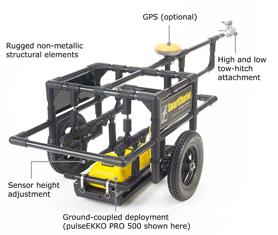
Mode of Operation:
The SmartChariot provides vehicle-towed deployment of pulseEKKO® 500 or 1000 MHz transducers with adjustments for quick attach and release. It attaches to a common trailer hitch on any vehicle of opportunity; cars, trucks and vans, but also ATV’s (all-terrain vehicles), tractors and even bicycles and motorcycles can be used.
The SmartChariot delivers seamless field operation with pulseEKKO® by including integrated, equispaced odometer triggering and GPS positioning. A mounting for GPS receivers is a standard feature. The SmartChariot’s integrated odometer is directly compatible with the pulseEKKO® data acquisition embedded software on the DVL. Data acquisition with the SmartChariot exploits Sensors & Software’s unique DynaQ® technology which provides dynamic stacking (averaging) of data while moving.
Environment & Application Characteristics:
The SmartChariot is ideal for surveys covering large, smooth, open areas that can be performed using a vehicle: roads, highway sections and bridges needing quick assessment, large parking lots, parking garages, warehouse floors, and open fields such as golf courses and parks. This configuration is optimal for surveys where large areas need to be covered quickly and systematically.
The embedded DVL-500 software provides easy to use Line Scan and Grid Scan mode which logs data in a structured format enabling quick creation of depth slices and post data processing in EKKO_Project and various GIS and CAD packages or in Google Earth. The bi-directional odometer triggers data acquisition when moved in one direction and provides back-up arrow positioning enabling real-time target mapping with field interpretations
Options:
The following optional items are available to customize the system for your needs.
- GPS to provide geo-referenced coordinates linked to the data
- Smaller or longer-life batteries depending on the time duration of measurements or portability requirements
- Variable transducer and GPS cable lengths depending on your requirements
Products:
The SmartChariot supports the pulseEKKO® 500 or 1000 MHz transducers.
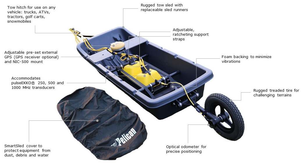
Mode of Operation:
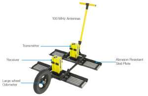
The pulseEKKO SmartSled configuration is designed for vehicle-towed surveying for pulseEKKO 250, 500 and 1000 MHz transducers over smooth to rough, open terrain such as agricultural fields, grass, gravel roads or rocky surfaces. The SmartSled attaches to a common trailer hitch on any vehicle, such as trucks, ATVs, tractors, golf carts or snowmobiles. Designed to deploy you’re the pulseEKKO transducers on various terrains, the SmartSled has built in straps to secure the sensors and maintain ground-coupling for maximum signal penetration.
SmartSled features:
- A wheel odometer to trigger data acquisition at default or user-defined intervals (step size) to provide uniform data coverage.
- Sensors & Software’s unique DynaQ® feature automatically adjusts data acquisition rates to the survey speed; providing dynamic stacking to maximize data quality
- When coupled with an external GPS, the SmartSled can collect large GPR pseudo-grid surveys that can be processed into depth slices using the EKKO_Project software module called SliceView-Lines.
- Adjustable mount for a GPS receiver (GPS optional) and NIC-500P for SPIDAR.
- Adjustable straps to quickly swap between pulseEKKO® 250, 500, and 1000 MHz transducers.
Environment & Application Characteristics
The SmartSled is ideal for large open surveys on varying terrains from smooth to rocky such as agricultural field, rocky roads and uphill terrains using a vehicle. This configuration is optimal for surveys where large areas need to be covered quickly and systematically.
The embedded DVL software provides easy to use Line Scan and Grid Scan mode which logs data in a structured format enabling quick creation of depth slices and post data processing in EKKO_Project and various GIS and CAD packages or in Google Earth. Data is displayed on the DVL-500 enabling real-time target mapping with field interpretations.
Options:
The following optional items are available to customize the system for your needs:
- GPS to provide geo-referenced coordinates linked to the data
- Varying cable lengths depending on your requirements
- Batteries of different sizes and capacities depending on field time or portability requirements
Products:
The SmartSled supports the pulseEKKO® 250, 500 or 1000 transducers.
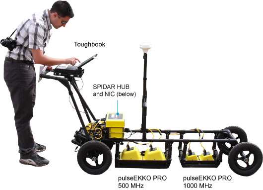
Mode of Operation:
For applications such as those requiring large area coverage or multiple frequency concurrent data collection, a wide variety of configurations can be build using the SPIDAR® architecture. From towing several units behind an ATV, to collecting data at several positions on a mining machine to deploying an array on a sewer inspection platform, our application specialists can help you design a configuration best suited to your unique operational needs.
Options:
The following optional items are available to customize the system for your needs.
- SPIDAR® NICs and SpiView control software
- A wide range of ancillary handles, odometers, control system housings and cables
- Custom carts and support brackets
- Wireless network for support for arrays
- GPS to provide geo-referenced coordinates linked to the data.
- Small or longer-life batteries depending on the time duration of measurements or portability requirements
Products:
pulseEKKO® systems can be deployed as array systems using the SPIDAR architecture.
Case Studies

Snow to Water
Snow is major source of fresh water. This case study shows how GPR provides key control information needed for converting snow pack to hydrological forecasts.
Learn moreLiterature
Leasing Options Now Available!
Contact us today to learn how you can get unbeatable lease options on our full range of Ground Penetrating Radar equipment with low monthly payments!


